geographic information system (GIS)
See the following -
3 Things To Know About Geomedicine
"Location, location, location" is a phrase that's long been associated with real estate, but in recent years it's also played a role in attempts by healthcare professionals to track disease. Now, some are putting health IT to work in adding location information – where patients have lived – into their EHRs. Read More »
- Login to post comments
An Open Source Mapping Primer
 As you've surfed the web, you've surely come across many sites using embedded maps to display data. Humans are visual creatures, so presenting temperatures, crime statistics, or population densities on a map often makes quickly discerning patterns and spatial relationships easier than presenting the same facts as a boring table. Visualizations based on maps can be quite sophisticated and even show patterns across time as well as space; Maps Mania is one blog showcasing many great examples of online maps. But displaying data on an embedded map doesn't need to be a complicated affair. You can do it using open source tools. In this post, I offer some tips for getting started doing this...
- Login to post comments
Digging Into The Open Source Geospatial Software And OpenGeo Suite 3.0
On October 2, OpenGeo released a major upgrade to the OpenGeo suite. The company expects users will be excited about enhancements in production and processing and a closer feature match to Esri’s ArcGIS Server. Rolando Peñate, OpenGeo’s product manager, answered our questions about open source geospatial software and the new release. Read More »
- Login to post comments
Government Agencies at all levels starting to use OpenStreetMap
There is a growing interest by the U.S. government in OpenStreetMap. The free availability of the rapidly maturing OpenStreetMap data and software makes this GIS mapping solution a more attractive option for the public sector than ever before, given the steep cuts in federal and local government budgets. Read More »
- Login to post comments
How Can Information and Communications Tech Help in Disaster Preparedness and Response?
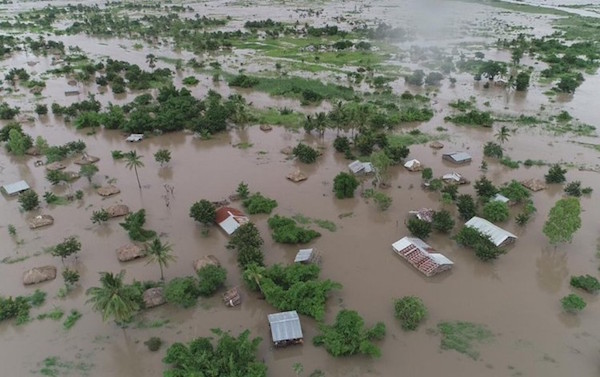 n the immediate aftermath of disasters, timely and effective information is critical for the decision-making process. Information and Communication Technologies (ICTs) play a significant role in mitigation, preparedness, response, and rehabilitation by facilitating the flow of vital information in a timely manner. To deliver and deploy telecommunications / information and communication resources (transportable, easy to deploy and reliable systems that are non-exclusive) in a timely manner in the event of disasters, the ITU has designed the ITU Framework for Cooperation in Emergencies (IFCE). Innovative technologies such as robotics, drone technology, GIS, and emerging technologies like artificial intelligence (AI), the Internet of Things (IoT), cloud computing and Big Data are transforming the complex process of disaster management.
- Login to post comments
One Decade on, gvSIG Offers Powerful Open Source GIS Tools
Ten years after gvSIG’s start by the government of Valencia (Spain), the open source geographic information system (GIS) offers a broad range of GIS solutions. The software tools are used in sectors such as town planning, public transport, health care and environment management. “Software has become of strategic importance. All the more reason that we need to be free to use this technology however we want”, says Álvaro Anguix, general manager of the gvSIG association. “Freedom is central to gvSIG, right from the start.”
- Login to post comments
thinkWhere Supports Global Humanitarian Project to Map Disaster Areas
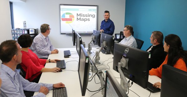 Geographic information and technology specialist thinkWhere is supporting the global humanitarian Missing Maps project by hosting a series of mapathons in Stirling, Scotland. In the evening of 13th June 2018, around 50 local community volunteers, including members of the thinkWhere team, will collaborate on a crowd-sourced Missing Maps data capture project. The fourth event of its kind organised by thinkWhere, it will be the first to be held at the company’s new premises at CodeBase, Stirling.
- Login to post comments
Yes, GIS Files Are Public Data, Too
Back in 2007, the Sierra Club requested a copy of what it thought was a public record from Orange County, California, covering information like the location and addresses of 640,000 land parcels in the county. Read More »
- Login to post comments
Latin OSGis Conference 2012
First Latin American Congress of Free and Open Source GIS - 2012
Free and Open Source Tools and Applications are rapidly increasing in number and quality. Many and different actors are involved in such a kind of process: large and small companies, professional practitioners, public agencies, universities, research centers but also simple map lovers. Read More »
- Login to post comments
Missing Maps Stirling Mapathon
Geographic information and technology specialist thinkWhere is supporting the global humanitarian Missing Maps project by hosting a series of mapathons in Stirling, Scotland. In the evening of 13th June 2018, around 50 local community volunteers, including members of the thinkWhere team, will collaborate on a crowd-sourced Missing Maps data capture project. The fourth event of its kind organised by thinkWhere, it will be the first to be held at the company’s new premises at CodeBase, Stirling.
- Login to post comments